GIS and Remote Sensing
Enabling Smarter Governance through Geospatial Solutions
PLAN Foundation is committed to strengthening urban governance and local self-government institutions through the effective use of Geographic Information Systems (GIS) and Remote Sensing technologies. We support Urban Local Bodies (ULBs) and government agencies in developing accurate, technology-driven spatial databases that improve planning, service delivery, and municipal administration.
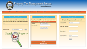
One of our key areas of expertise is GIS-based property mapping and House Tax Reform implementation. By integrating high-resolution spatial data with municipal property records, we help local bodies establish transparent, accurate, and efficient property tax systems. Our GIS solutions enable municipalities to identify unassessed properties, update existing records, improve tax coverage, and enhance revenue generation, thereby contributing to financially sustainable urban governance.
Our services include:
- GIS-based property and asset mapping.
- Preparation of digital spatial databases.
- Support for House Tax Reform implementation.
- Geospatial data collection and verification.
- Integration of GIS data with municipal records.
- Capacity building and technical support for Urban Local Bodies.
- Remote sensing-based analysis for planning and infrastructure management.
With a team of experienced GIS professionals and field survey experts, PLAN Foundation follows standardized methodologies to ensure data accuracy, transparency, and reliability. Our solutions empower local bodies to make informed decisions based on real-time geospatial information while improving operational efficiency and citizen services.
Completed Projects
PLAN Foundation has successfully completed GIS mapping and House Tax Reform projects for the following Urban Local Bodies in Himachal Pradesh:
- Municipal Council Sundarnagar, District Mandi
- Municipal Council Theog, District Shimla
- Municipal Council Rohru, District Shimla
- Municipal Council Dalhousie, District Chamba
- Municipal Council Chowari, District Chamba
- Municipal Council Nahan, District Sirmaur
- Municipal Council Baddi, District Solan
- Municipal Council Jawalamukhi, District Kangra
- Municipal Council Dehra, District Kangra
Through these initiatives, PLAN Foundation has contributed to strengthening municipal governance, improving property tax administration, and supporting the digital transformation of Urban Local Bodies across Himachal Pradesh.
As we move forward, PLAN Foundation remains committed to leveraging GIS and Remote Sensing technologies to create smarter, more resilient, and better-planned communities through innovative geospatial solutions.